Frequently Asked Questions
- Can I buy you a virtual beer or coffee?
- Can I print a map?
- How do I use a map?
- How do I Contact Free Map Tools?
- Can a tool be used to do XYZ instead?
- A Tool isn't Working for me
- Can I implement this on my website?
Can I buy you a virtual beer or coffee?
Q: Thanks for providing this service, can I buy you a virtual beer or coffee?
A: Many thanks for the offer, you can donate using the PayPal button below
We also be very grateful if you could do one or more of the following:
- Whitelist freemaptools.com on any ad blocking software you have
- Add a link to Free Map Tool from your website/blog
- Tell fellow colleagues or industry professionals about Free Map Tools
- Download the Free Map Tools iOS iPhone / iPad app
- Tweet about Free Map Tools
- Like Free Map Tools on Facebook
- Follow @FreeMapTools on Twitter
Can I print a map?
As the website is rendered in many different browsers, it is hard to have full control over this, however the general procedure is to switch to full screen view, print from the browser and adjust the scaling to get the best fit. Switching to landscape orientation is also helpful.
How do I use a map?
Pan
This moves the map up and down and from side to side. Much like sliding a page around on a desk in front of you. Click and hold the map using your left mouse button and then move your mouse to move the map OR use the pan buttons :

Simply click on one of the arrows to map the map along in that direction by one notch.
Zoom
Use the slider along the left hand side to zoom the map in or out :
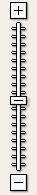
This will make an area larger so that you can see more detail.
Map Type
Use the Map Type Buttons to change the type of map displayed :
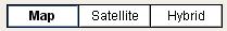
The 3 buttons show the following views:
- Map - A simple view that shows land, water, borders, cities and roads
- Satellite - A real life image of the area in question captured from a satellite. Some areas of the earth have a higher resolution than others such as large cities or tourist attractions.
- Hybrid - A combination or Map and Satellite views
Can a tool be used to do XYZ instead?
If you wish a tool do something similar but slightly different or in a different way please contact Free Map Tools using the online contact form. We do respond to most queries even if the answer is no!
How do I Contact Free Map Tools?
The best way to contact Free Map Tools is to use the online form. Remember to include your email address if you require a response. All efforts are made to respond to all enquires as soon as possible.
A Tool isn't Working for me
General Troubleshooting
Please try some of these steps to help resolve any issues:
- Close your web browser, reopen it and try to load the page again
- Clear the cache file of your web browser and reload the page
- Can you try to load the page form an alternative web browser?
- Can you try to load the page from an alternative device or computer?
Continued Issues
If after general troubleshooting something on this website still doesn’t work we do want to hear from you. Please contact Free Map Tools via email. Remember to include your email address if you require a response. Please provide details of..
- The page you are on (the URL address)
- The error/problem you are experiencing
- What you have done to make this happen
- What web browser are you using Internet Explorer / Firefox / Opera / Safari...
- What OS do you have? Windows / Mac / iOS / Android
- A screen shot of the problem if possible
All efforts are made to respond to all enquires as soon as possible, but please remember that Free Map Tools guarantees nothing is terms of support, only our good will to help users out.
Do You Offer an API?
Please get in contact to discuss.
Can I implement this on my website?
Free Map Tools does not encourage or support any functionality provided being implemented on other websites. There will be no free support given and no guarantee that any results will be accurate. If you wish to discuss custom / paid for solutions, please contact us.
Comments For This Page
Am I allowed to use this as a tool for mapping on Open Street Map?
By Jimmyisawkward on 23rd February 2024
When I use the new radius on the map tool, I can't click where I want the center of the radius. Whenever I click, I can only hold the map and move it.
By Celyver on 15th June 2023
How can I get a download link to the photo I have changed it gps?
On 14th February 2023
How do I hide the distance / the location labels ?
On 8th January 2023
The altitude map does not seem to be working.
On 23rd September 2022
Hello, is it possible to get a file of distances from a fixed starting postal code to all other postal codes within Canada?
By Mike G on 9th February 2022
Can you tell me the data source for the UK population data please
On 1st February 2022
Hi. How can I use API? I need "Find Cities Within Radius Map" API if it exists.
By Hayk on 21st November 2021
Are the elevations reported in elevation-finder geopotiential elevation or height-above-ellipsoid?
By Russell on 3rd November 2021
Which Api you use to do the zipcode generation by radius?
On 25th August 2021
Upload should be working again
By Free Map Tools on 29th June 2021
can i upload my selected zip codes to my pc? not sure what KML means, but when i do a upload it just sits and thinks
By Keith on 29th June 2021
Hi Chelsea, which page are you inputing the coordinates? Usually the format is latitude,longitude.
For example the Eiffel Tower would be 48.8582701,2.2943991
By Free Map Tools on 14th June 2021
I was wondering what format to put latitude and longitude coordinates? I cant seem to get it to work.
By Chelsea on 13th June 2021
Really liking the plot airport routes map... Thanx
Would like to help in anyway I can. Can't really donate so if there's something one could help with, let me know.
Great job!
By CaptnOgre on 13th May 2021
Can you tell me how accurate this information is and when the population census was last updated?
By JOhn on 14th April 2021
Lachie, which page/tool are you referring to?
By Free Map Tools on 9th February 2021
Can I input multiple postcodes at once? I tried using the XML import tool, but it told me my XML format was invalid. What is a valid XML format?
By Lachie on 8th February 2021
How to clear the elevation labels
By jeves on 25th October 2020
Hi Lisa, we are not sure which map (tool) you mean, but in general we only develop these tools to work on this website. There is no effort or consideration made to allow others to use the code on other websites.
By Free Map Tools on 14th September 2020
Showing the most recent 20 out of 116 comments. Click to see all the comments.
Add your own comment below and let others know what you think:
Comments
Your Name (optional)
