This article will describe how you can use Free Map Tools Find Population on Map to produce an estimate for the population inside a radius.
- Go to the page Find Population on Map
- Ensure the radius search is enabled

This article will describe how you can use Free Map Tools Find Population on Map to produce an estimate for the population inside a radius.
You can use the Find Population on Map tool to draw a radius or area and then find out the population inside that area.
To start, click either the radius or area icon.
Need to find a list of US Cities found inside a radius from a center point?
Using Find ZIP Codes Inside a Radius you can do this quickly. We will show an example of all cities in a 50mile radius of Denver, Colorado.
The Settings option inside the User Menu on Free Map Tools can be used to change the appearance of the markers on the map. You can adjust the size of the markers by selecting Large, Medium or Small. You can also change the opacity of the marker using the slider. A preview marker is displayed on the Settings window. Once you have the correct settings, click Apply. If you do not want to make any changes, click Cancel.
The Proclaimers once sang:
But I would walk 500 miles
And I would walk 500 more
To be the man who walked 1,000 miles
To fall down at your door
With this in mind, we can see on a map how far they would get …
See How Far the Proclaimers Can Walk
This was made using the Draw Concentric Circles page on Free Map Tools by drawing two concentric circles of 500 and 1000 miles from Leith, Scotland.
If you have a need to produce a map with a range of circles to indicate a series of radius from a central point, our Concentric Circles Map can be used.
This can be useful when it comes to estimating delivery zones or delivery charges for fast food delivery series for example.
In order to use the Concentric Circles Map, it is necessary to add lines of text with a particular format to the text box below the map. We will now show a few examples of how this can be done:
First, you need to browse to the page http://www.freemaptools.com/concentric-circles.htm
The format of each line is:
[Location] , [Start Radius] , [End Radius] , [Colour]
Where:
You can add one or many lines depending on how many concentric circles you require. We will now show a few examples of how this can be used.
Example 1: Delivery Zones in London
If we wish to express 4 delivery zones in London, England, each 5km apart, we can use the lines:
“London, England”,0,5,Blue
“London, England”,5,10,Green
“London, England”,10,15,Orange
“London, England”,15,20,Red
i.e.:
This will produce the following Concentric Circle Map:
Example 2: 100 mile to 150mile Range From New York
If we wish to illustrate an area between a 100 and 150 miles radius from New York with latitude/longitude of 40.7127, -74.0059 in purple, we could use the following line:
“40.7127, -74.0059”,100,150,purple
i.e.
Note: You can specify the units on the map. You can also use the Full Screen button to show the map in full screen mode.
This will produce the following map:
To create your own Concentric Circles, please visit the Concentric Circle Map page and try it yourself!
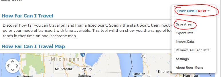
Following the addition of our new User Menu feature, we can show an example of how to use multiple pages on Free Map Tools and share data between them.
This scenario, is to list the USA ZIP codes within a ‘drive time’ radius. In this example we will find all ZIP codes within a 2 hour drive from Detroit, USA.
Procedure:

Your ZIPs are now returned!
Please use this example a basis for your own needs and uses across different pages on Free Map Tools
You can see how data is compatible between pages on https://www.freemaptools.com/about-user-menu.htm#featuretable
We have a new Facebook page found at https://www.facebook.com/FreeMapTools
Please visit and click Like!