
Category Archives: Guides

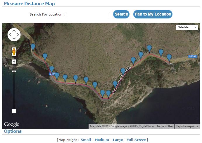
How to Draw a Route on a Map and Share
This guide will show how you can draw a route on a map and then share the route using a link.
Go to http://www.freemaptools.com/measure-distance.htm
Draw on the map by clicking
Draw an Area on a Map and Share
This article will explain how you can use the Area Calculator on Free Map Tools to draw an area, then share with others using a link.
The procedure is:
- Go to the Area Calculator
- Draw the area on the map
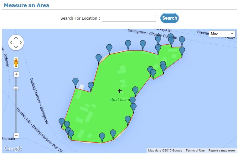
Draw an Area
Tunnel to the Other side of the World
In this guide we will show you can use the Map Tunnelling Tool to find out what point on the earth is directly below you.
Visit the Map Tunnelling Tool
Use the left hand map to find a position on the earth
The right hand map will then show where is directly below you, in other words the antipodal point.
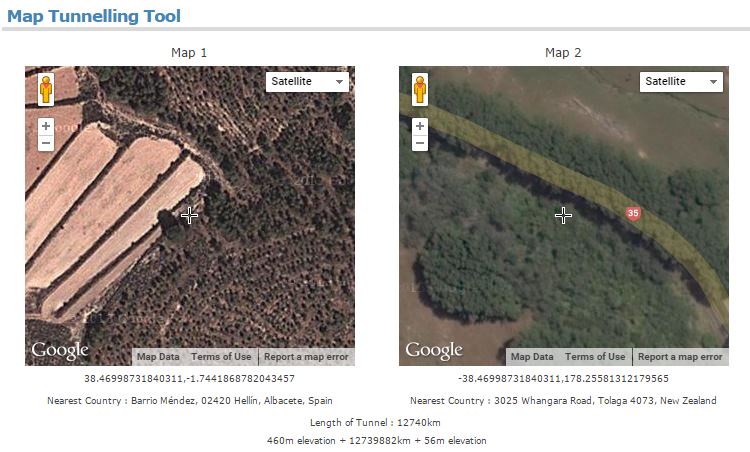
Tunnel to the Other Side of the Earth
Find Population Inside a Drive Time Radius
In this example, we will show how to use multiple pages on Free Map Tools to estimate the population inside a ‘drive time’ radius. We will then find the estimated population within a 1 hour drive from Atlanta, Georgia.
Procedure:
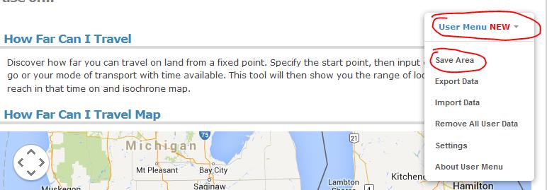
- Make your drive time radius. E.g. http://www.freemaptools.com/how-far-can-i-travel.htm?address=Atlanta,%20Georgia&speed=60&time=1&accuracy=10&u=km&hw=false&m=false&mode=DRIVING
- Once processing has finished, choose Save Area from the User Menu found near the top right of the web page
- Give the new area a name
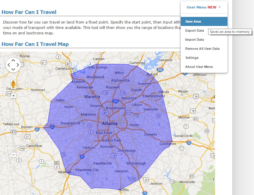
Drive Time From Atlanta
- Go to http://www.freemaptools.com/find-population.htm
- Choose User Menu > Load Area
- Click your new area name from the list to load it
- Click the Find Population button
How to Find Population Inside a Radius
This article will describe how you can use Free Map Tools Find Population on Map to produce an estimate for the population inside a radius.
- Go to the page Find Population on Map
- Ensure the radius search is enabled
![]()
Find Population
You can use the Find Population on Map tool to draw a radius or area and then find out the population inside that area.
To start, click either the radius or area icon.
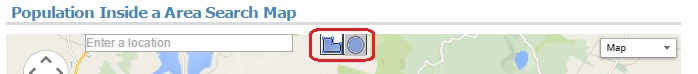
Population Choose Radius or Area
Find USA Cities inside Radius
Need to find a list of US Cities found inside a radius from a center point?
Using Find ZIP Codes Inside a Radius you can do this quickly. We will show an example of all cities in a 50mile radius of Denver, Colorado.
- Step 1: Visit Find ZIP Codes Inside a Radius
- Step 2: Add the input parameters of 50 miles and the center point of “Denver, Colorado” in to the text boxes

50 miles from Denver, Colorado
Drawing Concentric Circles on a Map
If you have a need to produce a map with a range of circles to indicate a series of radius from a central point, our Concentric Circles Map can be used.
This can be useful when it comes to estimating delivery zones or delivery charges for fast food delivery series for example.
In order to use the Concentric Circles Map, it is necessary to add lines of text with a particular format to the text box below the map. We will now show a few examples of how this can be done:
First, you need to browse to the page http://www.freemaptools.com/concentric-circles.htm
The format of each line is:
[Location] , [Start Radius] , [End Radius] , [Colour]
Where:
- [Location] is the location of the centre point inside a pair of double quotes. This can be a place name or a latitude / longitude value
- [Start Radius] – The radius where this concentric circle starts
- [End Radius] – The radius where this concentric circle ends
- [Colour] – The fill colour of the radius.
You can add one or many lines depending on how many concentric circles you require. We will now show a few examples of how this can be used.
Example 1: Delivery Zones in London
If we wish to express 4 delivery zones in London, England, each 5km apart, we can use the lines:
“London, England”,0,5,Blue
“London, England”,5,10,Green
“London, England”,10,15,Orange
“London, England”,15,20,Red
i.e.:
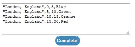
Lines used for Delivery Zones in London
This will produce the following Concentric Circle Map:
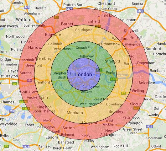
Delivery Zones in London
Example 2: 100 mile to 150mile Range From New York
If we wish to illustrate an area between a 100 and 150 miles radius from New York with latitude/longitude of 40.7127, -74.0059 in purple, we could use the following line:
“40.7127, -74.0059”,100,150,purple
i.e.
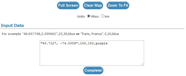
Text for 100 mile to 150mile Range From New York
Note: You can specify the units on the map. You can also use the Full Screen button to show the map in full screen mode.
This will produce the following map:
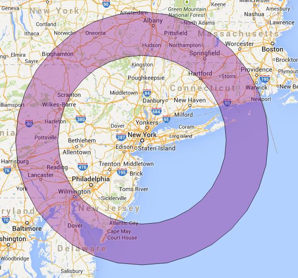
100 to 150 miles radius from New York
To create your own Concentric Circles, please visit the Concentric Circle Map page and try it yourself!
List USA ZIP Codes Within a Drive Time Radius
Following the addition of our new User Menu feature, we can show an example of how to use multiple pages on Free Map Tools and share data between them.
This scenario, is to list the USA ZIP codes within a ‘drive time’ radius. In this example we will find all ZIP codes within a 2 hour drive from Detroit, USA.
Procedure:
- Make your drive time radius. E.g. https://www.freemaptools.com/how-far-can-i-travel.htm?address=Detroit,%20Michigan,%20USA&speed=53&time=2&accuracy=10&u=km&hw=false&m=false&mode=DRIVING
- Once finished, choose Save Area from the User Menu
- Give the new area a name
- Go to http://www.freemaptools.com/find-zip-codes-inside-user-defined-area.htm
- Choose User Menu > Load Area
- Click your new area from the list to load it
- Click the Search For ZIP codes button
Your ZIPs are now returned!
Please use this example a basis for your own needs and uses across different pages on Free Map Tools
You can see how data is compatible between pages on https://www.freemaptools.com/about-user-menu.htm#featuretable