About The User Menu
The Free Map Tools User Menu is an addition to the Free Map Tools website intended to allow user-specific work to be saved, reloaded and shared between different pages on Free Map Tools.
There are a number of aspects to the User Menu:
- All actions are user specific. Nothing you do is available to other users unless you decide to share the XML export file.
- You do not have to use the User Menu in order to use Free Map Tools.
- All data stored can be removed quickly.
- All data is stored on your local machine. There is no server storage.
- Persistent data can be kept in the form of an XML file that you download, retain and upload at a later date. You hold your data.
- There are no logins, signups or passwords. We don't know who you are!
Explanation of Options
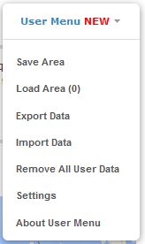
| Option | Explanation |
|---|---|
| Save [Area] | Save the [Area]/[Route]/[Radius] on the current page. |
| Load [Area] | Load the [Area]/[Route]/[Radius] onto the current page. |
| Export Data | Export all data held in memory to a local XML file. |
| Import Data | Import a previously exported XML file, overwriting existing saved data. |
| Remove All User Data | Removes all data stored on your machine. |
| Settings | Change various settings related to markers. |
| About User Menu | This page! |
XML Export
The XML export file can be used to:
- Backup your work
- Transfer your map data to another machine
- Share your data with others
Context Options
The options that appear in the menu depend on the page you�re on. Some pages have no save/load options, others allow saving and/or loading. There are three types you can save/load:
- Area
- Radius
- Route
Settings
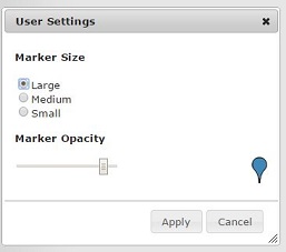
In Settings, you can change marker appearance: select Large, Medium or Small size, and adjust opacity with the slider. A preview marker shows live. Click Apply to save changes or Cancel to discard.
Feature Table
A table to highlight the options for saving and loading areas, radius and routes on pages on Free Map Tools. Generally you should aim to save a given type on one page and load it on the same or another page.
| Page | Load Area | Save Area | Load Radius | Save Radius | Load Route | Save Route |
|---|---|---|---|---|---|---|
| Radius Around a Point on a Map | - | - | - | - | ||
| Area Calculator Using Maps | - | - | - | - | ||
| How Far Is It Between | - | - | - | - | - | |
| Measure Distance on a Map | - | - | - | - | ||
| Distance Between UK Postcodes | - | - | - | - | - | |
| Find ZIP Codes Inside Radius | - | - | - | - | ||
| How Far Can I Travel | - | - | - | - | - | |
| Find Population on Map | - | - | ||||
| Find UK Postcodes Inside a Radius | - | - | - | - | ||
| Find UK Postcodes Inside a User Defined Area | - | - | - | - | ||
| Find ZIP Codes Inside a User Defined Area | - | - | - | - | ||
| Find Australian Postcodes Inside a Radius | - | - | - | - | ||
| Find Australian Postcodes Inside a User Defined Area | - | - | - | - | ||
| Draw Concentric Circles | N/A (Custom save/load on the same page) | |||||
| ...More to Follow... | - | - | - | - | - | - |
Suggestions and Bug Reports
Please contact us to highlight any bugs or suggest changes to the User Menu.
Comments
What happened to the ability to lable a marker?
HOW CAN I FIND COMPASS DIRECTIONS FRON ONE POINT TO ANOTHER
This is an excellent tool!
download link is gone
Should be working again now
as of Sunday 31st July 2022 The distance only shows as crow flies not land distance Please can this be fixed
Very disapointed
How can i calculate shipping distance?
I am trying t find the distance from my location in feet, and I cant seem to click on any part that will help me find it
map gold iran
How do you change The display s language
Raminta, sorry, this is not possible.
Hi, Can i upload a file with a list of locations (lat/ long or address) and get population estimate withing a certain radius for each of them?
Hi Paul, sorry, that is not possible.
Can I upload street addresses and zip code and see which ones are within a certain radius from a given address?
Map doesnt load
I do not see a "clear all labels" option, also i was starting to get -32,000 for every place i clicked when i zoomed way out.
This map shows cities and towns
The ground height of my house is 20 metres. What is the reference point where it is taken from ? Ie what or where is zero height.
Stuart, please try it again and let us know if it works now?
Showing the most recent 20 of 48 comments. See all comments.