Find Population on Map
Estimate the population within a custom-defined area on a map. By drawing a shape, selecting a radius, or inputting coordinates, users can calculate how many people live within that boundary. The tool uses population data overlays to provide real-time estimates, making it useful for planning, analysis, or research purposes. It's ideal for both personal and professional geographic population insights.
Get Started
You can search by a location name and radius, OR choose the circle / polygon icon on the toolbar and start drawing your area.
Inputs
Loading Map
Map Options
Output
Instructions
- Search, zoom and pan the map to find the desired location
- Toggle the Polygon or Radius draw tool by clicking on the icon on the toolbar on the map
- Click on the map to define the outside edge of the polygon. You can move the edges after it has been drawn. You can delete an edge by right clicking
- Once the area is defined, click the [Find Population] button to find the population inside
- After a delay, the estimated population is returned and displayed below the map
Other notes:
- Click the [Full Screen] icon on the map to view the map in full screen
- Click the [Zoom To Fit] button to zoom your map in/out on the area drawn
- Click the [Reset Map] button to start again
Data
Population data is from 2015,2020 & 2025 (estimated)
Example Population Estimate
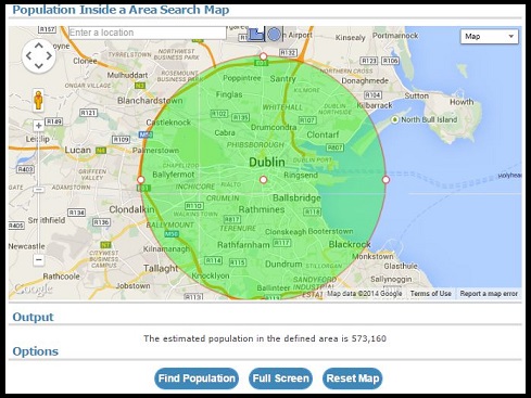
Screenshot of radius population estimate for Dublin, Republic of Ireland
Version History
- 27th May 2026 : Version 5.7 - Improved error handling
- 21st April 2026 : Version 5.6 - More updates to saving and loading functionality
- 19th April 2026 : Version 5.5 - Updates to saving and loading functionality
- 13th October 2025 : Version 5.4 - Population data for 2023 added
- 17th May 2025 : Version 5.3 - UI Updates
- 21st April 2025 : Version 5.2 - Location autosuggest stopped working. Alternative now in place
- 14th June 2024 : Version 5.1 - Performance Improvements
- 27th January 2024 : Version 5.0 - New option to specify epoch (year) of data
- 9th January 2023 : Version 4.2 - Improvements to drawing radius manually
- 6th November 2022 : Version 4.1 - Polygon search added
- 5th November 2022 : Version 4.0 - Up and running again with radius search
- 2nd October 2019 : Version 3.1 - Adding nodes to polygon no longer causes map to re-zoom
- 15th October 2018 : Version 3.0 - Converted to Leaflet maps
- 22nd March 2015 : Version 2.3 - Radius can now be drawn with a manual radius and location
- 15th January 2015 : Version 2.2 - Now displays circle radius in miles as well as km
- 8th November 2014 : Version 2.1 - Added Zoom to Fit button
- 15th July 2014 : Version 2 - Added radius circle search for population
- 15th July 2014 : Version 1.1 - Polygon Search now works clockwise and anticlockwise
- 28th June 2014 : Version 1 - Initial Version. Polygon Search
Comments
It just keeps saying "please wait" even after like 10 mins
City names are not auto populating
I keep getting zero for population estimate
I get 0 as estimated population, how come?
Legit, yes. Accurate, subjective, but treat it as an estimate.
it this legit ? and accurate
Bob, what size is the shape? There are "too small" and "too large" scenarios that will produce no results.
I keep getting error;no results when I make my own shape
Justin R, it should be working again
The auto-complete on city names is no longer working
Why doesnt 2020 work?
IMPORTANT NOTE: For those of you getting "The estimated population in the radius is 0"... to "fix"/help this issue, just make the radius of the circle to SMALLER than 70km^2 at a time. Sometimes it works for bigger radiuses, but often it doesn't; also, if your circle goes across multiple different countries, it can also mess up the tool. Hope this helps!
cool app i like the idea very much but it is SO SLOW and laggy takes way too long plus when i finally outlined my area and pressed find population i waited for like 5 minutes and it just said "please wait" the whole time and never loaded
This is great. Just what I need for a study that I am doing around certain population centers.
This is fantastic. Just what I need for a study of populations related to trails around the centers of certain cities that I am doing. Thank you.
It is still showing Zero for the population estimate.
It does the wrong population for Denmark
is still broken, only giving me a population of zero
Draw radius, clicked "Find Population" and continue to get "The estimated population in the radius is 0 Zero" as Output. Attempted multiple areas and defined radius manually and drew radius - nothing works.
Doesn't work in Finland
Showing the most recent 20 of 308 comments. See all comments.