Free Map Tools
An online resource that enables visitors to easily and quickly use maps in order to measure, search and overlay elements on maps for a wide range of useful applications, for free. Click on one of the Map Tools below to find out more...
Popular Tools
A list of more popular map tools that are available for you to use for free. There is a more comprehensive list of map tools and resources here.
Radius Around Point
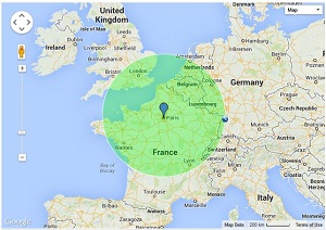
The Radius Around Point tool lets you draw a circle of a chosen radius around any location on a map. You can enter an address, coordinates, or click directly on the map. The radius can be set in kilometers or miles, and the circle updates instantly. This tool is great for tasks like planning delivery zones, estimating travel distances, or analyzing coverage areas. You can also export the data, share the map, and adjust the radius as needed. It's simple to use and works well on both desktop and mobile devices.
Measure Distance
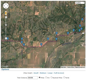
The Measure Distance tool allows users to calculate the distance between two or more points on a map. Simply click to set start and end locations, or continue clicking to measure a route with multiple segments. The tool displays the total distance in kilometers, miles, or nautical miles. It's ideal for planning walking, running, cycling, or driving routes, as well as measuring straight-line distances. Users can reset the map, undo points, and share or export the results. The interface is easy to use and works across desktop and mobile devices for convenient, on-the-go measurements.
How Far is it Between
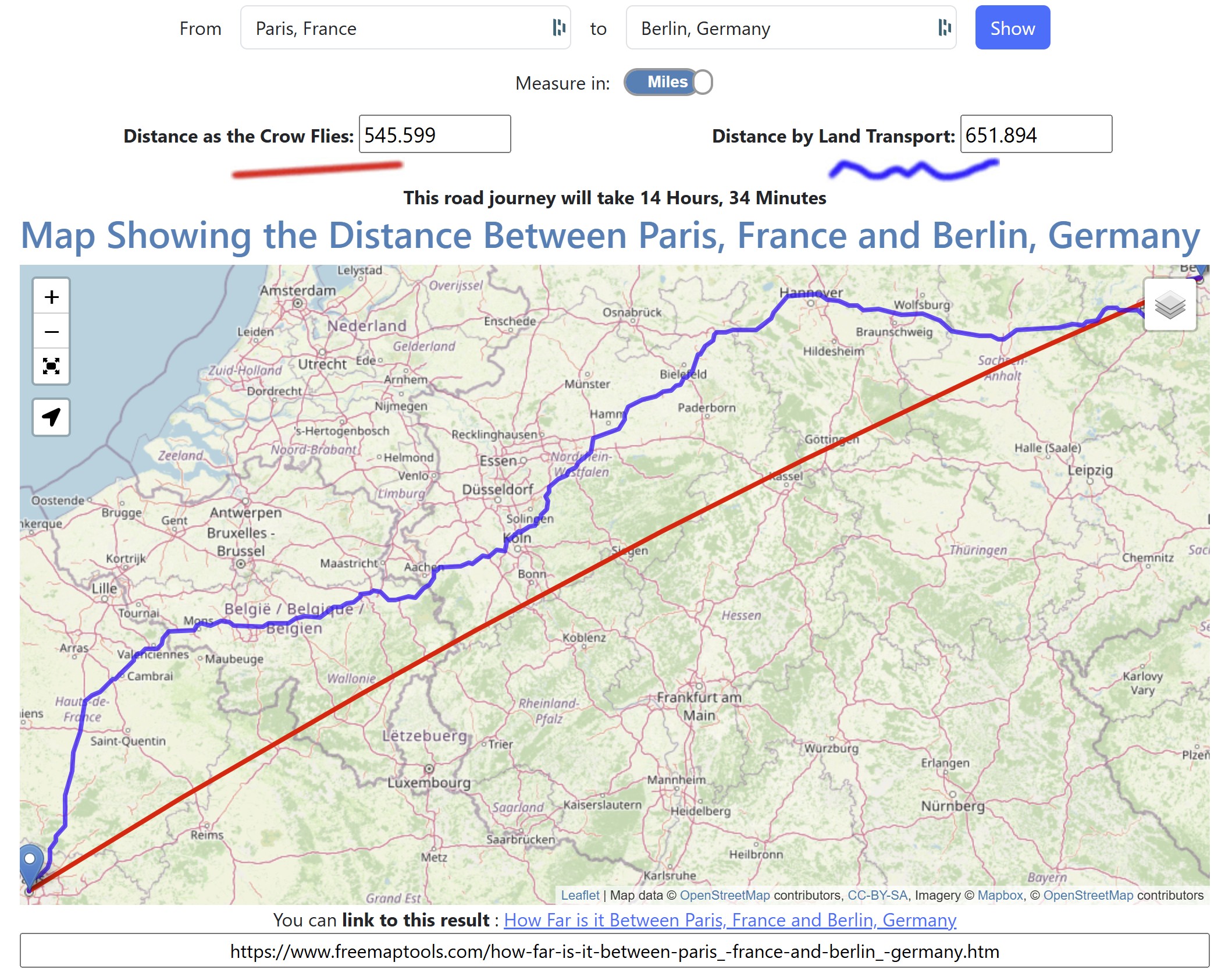
The How Far Is It Between tool calculates the distance between two locations anywhere in the world. Users can enter place names, addresses, or coordinates, and the tool will display the straight-line distance ("as the crow flies") between them. It shows results in kilometers, miles, and nautical miles. A map visually plots the route, helping users better understand the distance and relative position. This tool is useful for travel planning, geographic comparisons, and general curiosity. It's simple to use, with a clean interface that works on both desktop and mobile devices.
Area Calculator
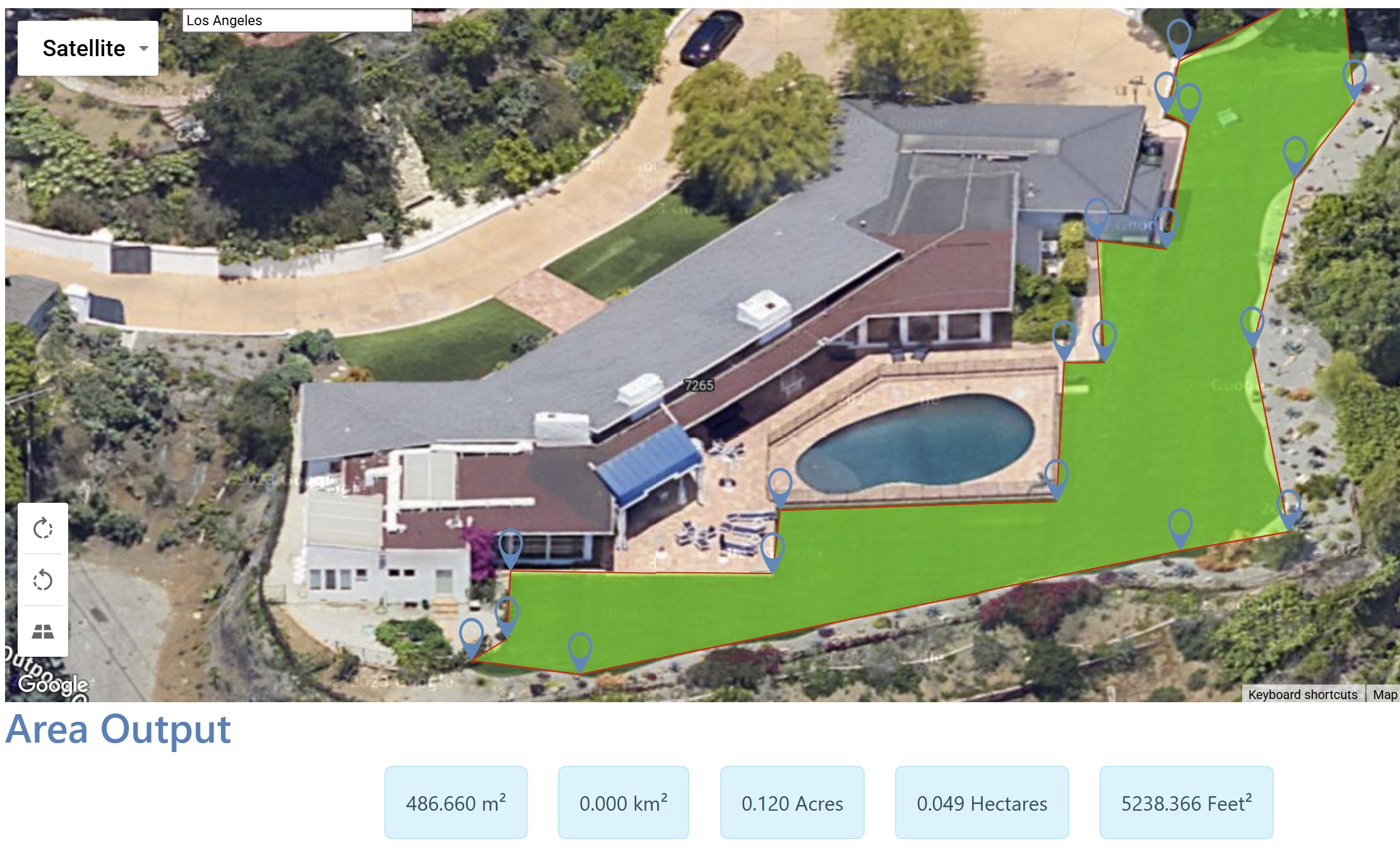
The Area Calculator Tool enables users to measure the area of any region by drawing directly on a map. You can click to set points and outline a shape, and the tool calculates the enclosed area in square meters, kilometers, feet, miles, and acres. It's ideal for estimating land size, planning construction projects, or checking property boundaries. Users can edit points, reset the shape, or export the data for further use. The intuitive interface works well on both desktop and mobile devices, making it accessible for professionals and casual users alike
Country Specific
To see a list of tools specific to a country, use one of the links below:


Site News
Recent news about Free Map Tools website.
How Far is it Between Upgrade
How Far is it Between has been updated with Distance by Vehicle, plus optional Distance by Bike and Distance by Walking outputs. The action button is now Search, route mode selections are preserved in shared URLs, and the result icons now use dynamic colour-coded SVG route previews.
Added on 27th May 2026 in Update
Time Zone Converter Major Upgrade
The Time Zone Converter has been fully refreshed with a faster, modern map experience and smarter conversion tools. It now includes accurate timezone-aware date/time conversion, 12/24-hour display toggle, draggable points, one-click swap points, shareable result URLs, reset map, and a cleaner interface for an easier workflow.
Added on 21st May 2026 in New Feature
Citation Generator
Use the Citation Generator to make a Harvard, APA or MLA Citation fo any page on the website
Added on 12th November 2025 in New Feature
Site UI Update
Free Map Tools has been updated with a new site layout.
Added on 16th May 2025 in Website
Convert UK Postcode to Latitude / Longitude
Performance improvements made. Now finds old/terminated postcodes
Added on 23rd April 2025 in Update
General Tools
Map tools that are relevant to all locations worldwide.
- Area Calculator Using Maps - Find an enclosed area using a polyline on a map
- Create and Plot Encoded Polyline on Map - Plot an encoded polyline on map and draw a polyline to produce an encoded polyline
- Direction Projection Tool - Use the Direction Projection tool to visualise a projected path on a map
- Draw Concentric Circles - Draw Concentric Circles on a map
- Elevation Finder - Find an estimate for the elevation of a point on the earth
- Find Cities and Towns Inside an Area - Find cities and towns within a user drawn area
- Find Cities and Towns Inside Radius - Find cities and towns within a particular radius of a central location
- Find Line of Equidistance Between Two Points - See the path where the distance between two points is the same
- Find Place With Name - Search for a town, city or place with your name
- Find Places Within Radius - Search for places inside a radius of an address
- Find Population on Map - Define an area on a map then find out the estimated population inside
- Find Sunrise and Sunset Time at a Location - Find out the next sunrise and sunset time of any point on the earth.
- Golf Shot Distance Calculator - Record and measure the various strokes required to complete a hole of golf on a map
- Horizon Finder - Find where the visible horizon is from a point on earth using a map
- How Far Can I Travel - Find out how far you could travel by road in a set time
- How Far Does Santa Have To Travel - Find out how far it is between the North Pole and your house
- How Far Is It Between - Find the distance between two named points on the earth
- International Meeting Centre of Gravity Tool - Find the best place to hold a meeting for it's attendees by inputting various international addresse
- KML File Creator - The KML (Keyhole Markup Language) File Creator will allow you to produce KML files using a simple in
- Map Tunnelling Tool - Tunnel to the other side of the earth on a map
- Measure Distance From Central Point To Many - Find out the distance from one point to many other points
- Measure Distance on a Map - Take a measurement between two points on a map to find the distance
- Plot Airport Routes - Plot airline route networks or airport destination maps
- Radius Around a Point on a Map - Find where a radius of specified distance falls around a point on a map
- Range Finder Tool on a Map - Find out the end point location when you specify a start point, a bearing and a distance on a map
- Save Route on Map - Save a route on a map
- Time Zone Converter - Convert a time in one location to the time in another location
- Trip Calculator - Calculate the time and distance for a trip on a map
- Tunnel to the Other Side of the Google Earth - Find out what is on the other side of Google Earth
- View and Edit Photo GPS Data - Use a map to view and edit GPS data in a photo
Free Map Tools makes use of the Leaflet Maps, PHP and Ajax. This site is always being developed and improved, so check back often to see what has been updated.
Comments
I like this tool. It really helps determine elevation.
𝑀𝑖 𝑝𝑖𝑎𝑐𝑒 𝑓𝑎𝑟𝑒 𝑚𝑎𝑝𝑝𝑒
How about maps with an ai search, e.g. "Where in the u.s.a was skateboarding popular in 1970?" That would be AWESOME!
cool map cheers mate
Awesome!!!
Very cool. Thanks! --from the UK
Good maps. Thx
Awesome map I use for genealogy, this is the best! Small fix, you have to add the distance before you type the location or the screen keyboard covers the input field for the location.
not able to use the map
The website has not night theme, the light of screen is so hard to eyes.
Invaluable for planning RV trips !
i love map
How can I get this map?
Thos is the best service of ant
I think it's a good project.
Bon outil
Bon outil
This site is very useful but im either having trouble finding the app or it doesn't exist. If it doesn't exist i would find it very convenient to make one.
This is a good tool think you
IT GOOD
Showing the most recent 20 of 320 comments. See all comments.