Line of Equidistance Between Two Points
See the path where the distance between two points is the same at all times.
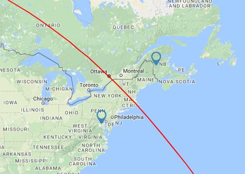
Line of Equidistance Between Two Points Map
Loading Map
Feedback
Line of Equidistance Between Two Points Tool
- Click / Tap on the map to place the first marker
- Click / Tap on the map again to place the second marker
- A path will then be drawn between the points to show where the path of equidistance is
- You can then either drag a marker to reposition it or click/tap again to make a new path
About
The Line of Equidistance Between could be used to work out a boundary line or confirm which locations are closer to one point or another.
Future Ideas and Features
- Increase length of line
Version History
- 23rd November 2025 - Line drawn now extends further
- 8th January 2024 - Bug fix
- 13th February 2020 - Convert to Leaflet Maps
- 17th July 2017 - Initial Version
Comments
i want to be able to export it
increase line length please!
Anyone having issues with the page lately?
(continued from my immediately previous comment). ... in fact, it appears from the example image that it might have worked the way I'm suggesting at some point in the past; the line there is much longer than the one currently drawn for those same two points.
Would you consider making the line longer, possibly even a full trip around the globe? Currently, the line length is somewhat proportional to the distance between the two points -- two cities quite close together yield a very short line of equidistance. Thanks!
Make it possible to do more than two points, to find regions where every point in that region is the closest to one point
Should be working again...
Seems to have stopped working :(
More points for regions closest to each point
I want to meet at a bar that minimizes driving distance for most people. I would like to find that with an app that uses google maps.
It would be great if one could manually enter an address and/or Latitude/Longitude. Thank you.
At the moment this only shows the line for the "short way" around the world - it would be interesting to see the rest of it!
What is the answer to the first comment. Can I mark multiple points between and inline with the first 2 points?
I'm looking for an app to help me determine a straight line between two points on my property. Then make several Mark's between the two points so I can put up a fence along my property line. There are woods and a creek and cannot see from one side to the other.
If you select somewhere in south america (near the south) and in australia (near the pacific) you'll get a line that cross both points instead of an equidistant one. Doesn't seem to work properly between the two continents
I want draw my quard... To googl ma
This tool does not provide the same results as Google Map...
Would be great to have a version of this for driving: What is the midpoint-line between two points on the road? Perhaps let the user be able to set a length for this line (the 500-mile-long mid-point line). Similar to the "How far can I travel" tool.
Equidistance lines between three points, dividing the map in regions closer to a given point