List of UK Related Map Tools
There now follows a list of all the tools available on Free Map Tools that relate to the UK. This includes UK Postcode tools for England, Scotland, Wales, Northern Ireland and the Channel Islands
 UK And UK Postcode Related
- Convert NGR to Postcode - Convert an OS National Grid Reference to a UK postcode
- Convert Postcode to National Grid Reference - Type in a postcode and the NGR will then be displayed
- Convert UK Postcode to Latitude / Longitude - Convert a UK postcode to a latitude longitude pair
- Distance Between Full UK Postcodes - Find the distance between 2 full postcodes in the UK and see the route on a map
- Distance Between OS Grid Coordinates - Find the distance between 2 OS grid coordinates in the UK and see the route on a map
- Download UK Postcode Area Boundaries - Download a KML file showing all UK Post code area boundaries
- Download UK Postcodes with Latitude and Longitude - Download a list of UK out code postcodes with their latitude and longitude coordinates
- Find British National Grid Reference From Map - Tool to find the British national grid reference from a map
- Find Closest UK Postcode To Custom Postcode List - Upload a list of UK Postcodes and then determine which postcodes are closest
- Find London Underground Stations Inside Radius - Specify a point and a radius to search within and return all London Underground stations inside
- Find UK Hospitals Inside a Radius - Tool to find UK hospitals Inside a specified radius
- Find UK Postcodes Inside a Radius - Specify a point and a radius to search within and return all outcode postcodes inside the radius
- Find UK Postcodes Inside a User Defined Area - Define an area and then search to return all outcode postcodes
- Meeting Centre of Gravity for Post Codes - Find the best place to hold a meeting by inputting postcodes
- Radius From UK Postcode - This tool will allow you to plot a radius around a point on a map.
- UK Petrol Station Map – Find Cheap Fuel & Live Prices - Find UK petrol stations near you with our interactive map. View live fuel prices including E10 petrol and diesel, filter by car wash, toilets, water filling and
- UK Postcode Map - Map of the UK where you can see the locations of all area level / out code postcodes
- Walking Distance Between UK Postcodes - Shows the walking distance between two postcodes
Downloads
Downloads for UK data
Offline Tools
Tools in this section can be downloaded and run locally on your computer. These offline map tools work directly in a web browser, require no installation or accounts, and are ideal for UK postcode and distance calculations without relying on always-online mapping services.
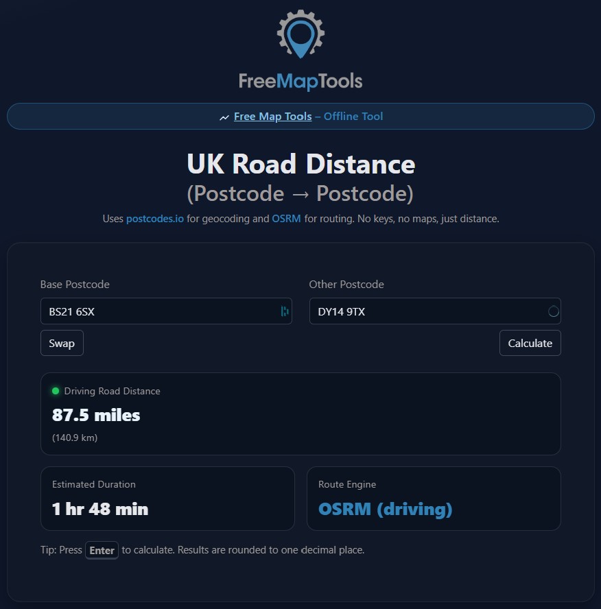
UK Postcode to Postcode Road Distance Tool
The UK Postcode to Postcode Road Distance Tool lets you quickly calculate real driving distances between any two UK postcodes. It runs directly in your web browser, with no installation, accounts, or API keys required. Simply enter two postcodes and get the road distance in miles and kilometres, plus an estimated driving time.
Designed to be lightweight and reliable, the tool uses trusted open data sources and can even be run locally on your own computer. Ideal for planners, developers, businesses, or anyone who needs quick UK distance calculations without maps, clutter, or subscriptions. Free to use, forever.
About UK Map and Postcode Tools
The United Kingdom is one of the most frequently searched regions for postcode and mapping data. The UK is made up of England, Scotland, Wales, Northern Ireland, and the Channel Islands, each of which uses the UK postcode system for addressing, navigation, and location-based services.
The UK-related tools listed on this page are designed to help users work with British geographic data in a simple and practical way. This includes tools for UK postcodes, distance calculations, coordinate lookups, and general mapping tasks. UK postcodes are alphanumeric and structured in multiple levels, making them widely used in logistics, planning, research, and software development.
Many people use UK map tools for everyday purposes such as checking distances between towns and cities, converting latitude and longitude values, or validating postcode locations. Others rely on these tools for more technical tasks, including data analysis, application development, transport planning, and geographic research.
UK postcode tools are particularly valuable because postcode areas often do not follow county or local authority boundaries. Having access to accurate postcode data helps users better understand location coverage, delivery areas, and regional relationships across the UK.
Free Map Tools also provides downloadable UK datasets and offline tools for users who need local access to postcode and mapping data. These tools are useful when working without an internet connection or when processing large volumes of UK location data on a local computer.
All tools on this page are web-based, easy to use, and require no specialist GIS software. They are suitable for casual users, developers, businesses, researchers, and anyone who needs quick access to reliable UK geographic information.
This page acts as a central index of UK-related mapping tools available on Free Map Tools. By grouping UK map utilities, downloads, and offline tools together, users can quickly find the resources they need without searching across multiple pages. New tools and updates are added over time in response to user demand.
If you have any suggestions for possible tools to use then get in contact.
Comments
Thomas, you can use Measure Distance on a Map to measure it.
Hi, how can I measure the distance from a postcode to the nearest river/stream for insurance purposes? Thanks
wheres the distans
How do I batch convert Latitude & Longitude to UK postcode
good website
Thanks for all your great work providing and maintaining the maps, tools and site. Very impressive.
This is a fantastic resource! Thank you for making this available for free public use.
Hi Tim. Sorry this is not possible.
Hi, can the map show areas of specific heights above sea level? Say, all areas above five meters.
I can plan my dog walks now and forever,YAY!
Hi Ken, we don't/can't show the area of an individual postcode unit unfortunately.
First time I've been here and it's looking impressive .. thanks. Much more potential than I'm going to use but several things I like to come back to juggle with. How ever I've not been able to make it do what I came for. Can't imagine it wont but after several attempt to poke it .. I've failed :( Please feel free to make me kick myself by pointing out the obvious I've missed: I can't make it show me the areas encompassed by a complete UK post code.Selling sites must access this information as when you enter a complete post code they frequently ask you to pick which of a handful of addresses you wish to choose but so far I've failed to effect that as an area on the map.
Sal Quao, every couple of months
Hi, Can you please let me know how often these postcodes refreshed to ensure we have the latest information. Thanks Sal
Hi Ben, If you can give some example browsers where it doesn't work, we can look in to this.
The map doesn't always load, depending on where I'm opening your website and which browser I'm using. I can see Google Maps on all these PCs.
Hi Paul, Convert NGR to Postcode has been added.
Looking at UK related. Okay you can "Convert Postcode to National Grid Reference" but why can't you go the other way ie "Convert National Grid Reference to Postcode"? Can't be that much more work to offer this can it!?
Excellent and so quick.
FreeMaPTools is an excellent site enabling one to carry out all sorts of useful operations.
Showing the most recent 20 of 23 comments. See all comments.